Friday, December 22, 2006

Hike to the Active Lava Flow

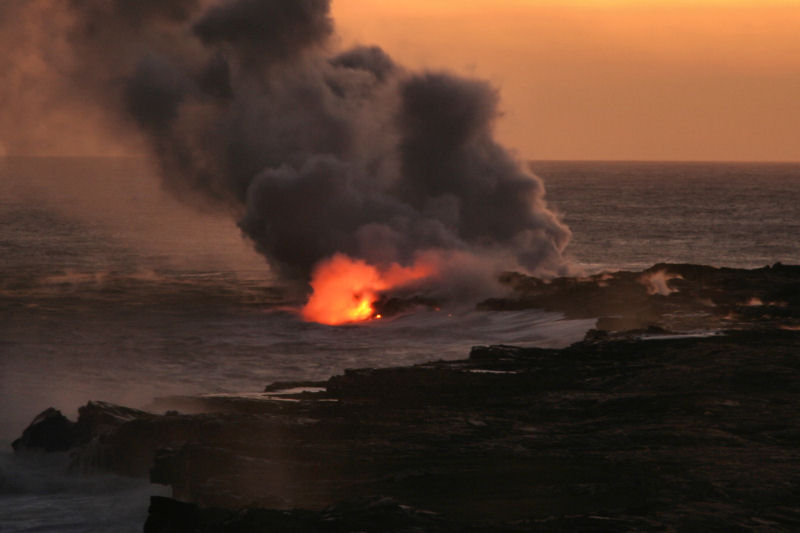
We decided to hike once again to watch the active lava flow of Kilauea volcano at the Hawaii Volcanoes National Park. We have done this many times now, but wanted to do it once more - plus, we have some new camera equipment that we wanted to try out. As usual, we stopped in to the visitor's center to ask them about the lava conditions and how long the hike would be (the conditions change almost daily). On this occassion it turned out to be about a 3.5 mile hike each way.

We chose to start the hike in the late afternoon to ensure we arrived at the viewing spot prior to sunset - that way we get to see the lava flow as the sky and sun change in the early evening. Also, this way we only have to hike one way in the dark. We were prepared with sturdy hiking boots, lots of water, jackets (it frequently rains here), one flashlight per person, and of course our camera equipment including tripod.

It was not surprising to see so many people unprepared for the long hike - many with open-toed sandals, many without water or even a flashlight. On our return hike from the lava flow back to the car, as we crested a hill, we came across a young girl about 20 years old, alone and crying in the dark. We tried to console her and see if she needed any help - it tourned out that the hike was too long and she did not want to go further, so her friends just left her on this hill in the dark with no flashlight, in the wind with a light rain beginning to fall! At this point she was about 1.75 miles from the car and the same distance to the lava flow - too far to walk alone in the dark with no light. The last group of hikers we saw were starting their hike at 8:00PM - which puts them back at the start somewhere around 1:00AM! Be smart when you hike in Hawaii - nature can be unforgiving.

The hike was definitely worth it - it was a surreal setting with the crowd silent in the dark watching the dramatic lava flow as the sun set in the background. The bright flashes of lava entering the ocean, and the hard-hitting waves pounding the shore mesmerized you. We got back to our car at about 9:00PM and we were starving! I had left me dinner in the car not thinking that I would be hungry long before this - so we chowed down on some stir-fried noodles that we had bought earlier and then drove back to Hilo for the night.

Labels: , ,

Tuesday, December 19, 2006

Hike the Pololu Valley

We revisited the Pololu Valley and hiked down to the bottom once more. Previously, earthquake damage had closed the Pololu Valley trail, but it is once again open - and it is a hike that you must do! The scenery is breath-taking with the rough ocean waves crashing against the sea cliffs and black sand beach on one side, and the densely forrested valley on the other. Like all things on the Big Island, the Pololu Valley is diverse and fertile. From this photo, you can see the series of gorges and valleys from the Pololu Valley (foreground) leading to the Honokane Nui, and eventually to the Waimanu Valley and ending up in the Waipio Valley. We saw swimmers braving the rough waters and a variety of hikers from young kids to older enthusiasts. The hike is an easy one, about 25-minutes from the parking lot at the lookout. Drive north from Kona and take Highway 270 to the end and park at the overlook.

Labels: ,

Tuesday, December 12, 2006

Kiholo Bay, Kona

I finally found the trail that leads you from Highway 19 to Kiholo Bay. Kiholo Bay is like an oasis surrounded by the barren Kona lava fields and twisted brush and trees. There is a black sand beach on one end and a beautiful tree-lined inlet on the other end. There are various clear-water ponds brimming with fish in and around the bay. You can see Kiholo Bay from the scenic overlook at mile-marker 82 on Highway 19. It's about a one-mile hike from the highway to Kiholo Bay. It wasn't as easy as I thought to find the trail from the parking area on Highway 19 (about miles north of the overlook). I had the parking area coordinates in my GPS (N19.8520, W155.9133), but I still had to search for the faint trail (N19.5104, W155.5449). Then it was fairly easy following the trail towards the ocean. There is a family of wild goats that lives in the brush alongside the trail - keep an eye out for them - I was able to photograph the adult, adolescent and even two of the young "kids". Continuing on the trail you will eventually pass a twisted dried-out trees off to the right of the trail - the trees and underbrush are so dense that taking a short-cut through them proved impossible. The day was pretty hot and I was glad I brought my water bottle with me! I continued past a gated entrance and eventually passed many palm trees a few shallow ponds in the shady beneath the trees, and finally I started to see sand as I approached the shore. I was excited - for the many many times I had spotted this little oasis from the highway, I never knew how to get to this place. I was finally here!

Labels: ,

Monday, December 11, 2006

New Inter-Island Airline

I just flew from Oahu to the Big Island today. I got a chance to try out the new inter-island upstart called Go! (a subsidiary of Mesa Airlines). They fly Regional Jet (RJ) aircraft between the Hawaiian Islands. The have started a mini price war between all the other inter-island airlines (such as Aloha and Hawaiian Air) due to their cut-rate budget prices. All-in-all I enjoyed my flight on Go! Airlines - one quirk about them is that you depart out of the Commuter Terminal at Honolulu International, which is a separate, smaller building set aside next to the regular inter-island terminal. If you want to save money, check out IFlyGo.com

Labels:

Sunday, December 3, 2006

Big Island Earthquake Update

Pololu Valley Trail Reopens, 11/21/06Update 11/21/06 - State officials have reopened the Pololu Trail in North Kohala, part of the Old Government Road that leads to an area called Awini where Kamehameha I was hidden from enemies in his early childhood.The trail, down a 420-foot cliff face, had been closed since the magnitude-6.7 and 6.0 earthquakes on Oct. 15. Following the quakes, sections of the trail were subject to continuing rockfalls, said Department of Land and Natural Resources Director Peter Young.

Due to the earthquake, there were sections of trail that were subject to continuing rockfall, that have now been scaled back and rebuilt in the areas that were unstable. Also, an approximately 20 foot section of the trail surface along a switchback was re-built to accommodate access. The trail surface had narrowed due to slippage. Various sections of the trail, which runs in a steep zigzag down the vegetated cliff face, have been rebuilt.

Labels: